Storm Éowyn stands as one of the most intense and memorable windstorms in UK and Irish history, impacting millions, setting wind and pressure records, and redefining emergency response practices in January 2025. Through a detailed exploration of how the storm formed, its impacts, and the lessons learned, this article captures every key aspect of Storm Éowyn’s legacy.
Origin and Naming
On January 21, 2025, meteorological models predicted a fast-deepening Atlantic system. The UK Met Office officially named the disturbance “Éowyn” after a public nomination, highlighting its potential for high-impact weather before it had even fully developed. This proactive communication would become crucial to public safety, allowing for broad readiness ahead of the approaching storm.
Key Details:
Meteorological Milestones
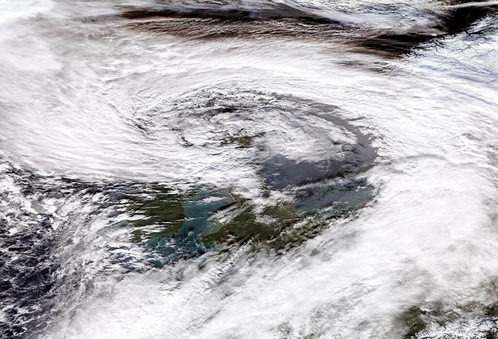
Storm Éowyn was an extraordinary example of explosive cyclogenesis or a “weather bomb” Its central pressure plunged 58 millibars in just 24 hours, meaning the storm rapidly intensified over the Atlantic. The lowest pressure recorded was 939–941.9 hPa (varied by station), setting a new low since the initiation of the modern UK storm-naming system and the deepest value since 2013. An unusually powerful jet stream, along with strong contrasts between Arctic and tropical air masses, enabled this rare strengthening.
Sting Jet Phenomenon
One dramatic feature of Éowyn was the likely formation of a sting jet, a narrow, short-lived region of hurricane-force winds within a larger cyclone. Evidence from satellite imagery suggested a strong jet struck the west of Ireland, where the highest gusts occurred, reminiscent of the infamous Great Storm of 1987.
Record-Breaking Winds and Tides
- Ireland: Mace Head, County Galway, reported a peak gust of 184 km/h (114 mph), shattering an 80-year-old record. Tidal surges at Limerick Docks and Galway Port nearly reached 3 meters, setting all-time records for water levels.
- Scotland: Drumalbin endured a 100 mph gust; at least 15 UK weather stations broke their January wind records.
- Norway and Wales: Wind gusts regularly topped 90 mph. Offshore, waves soared above 10 meters, menacing shipping and coastlines.
The Path of Destruction
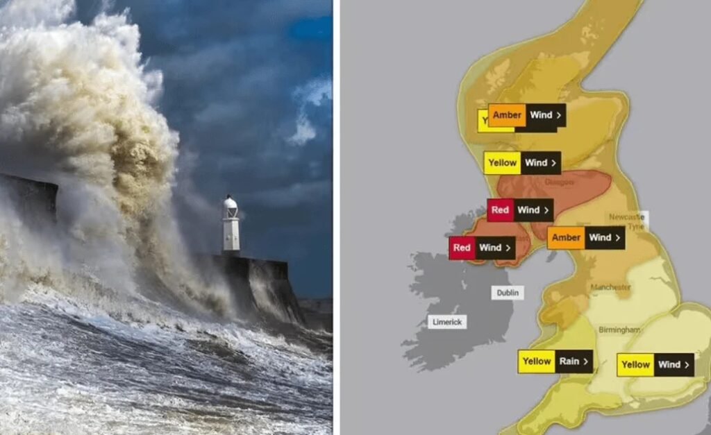
Between January 24 and 25, 2025, Éowyn swept across Ireland, the Isle of Man, Scotland, and Norway. Red weather warnings blanketed the nations: authorities closed thousands of schools, halted public transport, and advised millions to shelter at home for over 24 hours.
- Major infrastructure was damaged, power lines collapsed, wind turbines and buildings were destroyed, animal sanctuaries were destroyed, and tens of thousands of trees were felled; many regions reported that two years’ worth of downed trees occurred in a single night.
- Coastal and riverside towns have long been reckoned with historic floods and storm surges.
Human and Economic Impact
The storm’s human toll included at least one reported fatality when a falling tree struck a car in County Donegal, Ireland. Over a million homes and businesses lost power, with some waiting days for restoration.
Families faced widespread disruption with anxiety and stress in communal experiences. Animal centres were devastated, and community organisations were essential in organising recovery, providing shelter, and coordinating resources.

Economic and Insurance Losses
Initial insurance estimates calculated losses at €619 million, which were later revised upward to approximately €747 million (£650 million). This reflected a balance of property, commercial, and business interruption claims across the UK and Ireland. The scale of infrastructure damage and loss of business continuity will inform future insurance modelling and urban resilience planning.
Forecasting, Communication, and Warnings
The development of Éowyn illustrated both the advances and challenges in modern weather forecasting. The Met Office’s early forecasts (as far back as January 15) highlighted the chance for severe weather, and confidence grew steadily as the models converged on a high-impact event. The Met Office issued its first warnings on January 20, ramped up communications as confidence strengthened, and named the storm on January 21, days before it even formed.
In the run-up and during Éowyn’s landfall:
- The Met Office’s website received over 14 million page views; weather warnings alone were viewed more than 2 million times between January 21 and 25.
- Coverage was extensive, with over 23,000 media mentions and 14 million social impressions.
- Briefings were coordinated with emergency services, government departments, and infrastructure managers.
- Public engagement on YouTube tripled, with the channel’s highest daily views to date, illustrating the public’s intense need for real-time information.
Emergency Response and Societal Resilience
Authorities and first responders acted quickly, aided by pre-emptive briefings from meteorological agencies. The RAC, for instance, monitored and reported a significant drop in breakdowns in the worst-hit areas, proof that many heeded warnings and stayed off the roads during the worst conditions.
Community and volunteer response was notable: thousands offered help with debris clearance, delivered food and essentials to isolated families, and provided support for animal shelters and vulnerable groups.
Public Reaction, Technology, and Criticism
Éowyn brought to the fore debates about:
- National infrastructure resilience (especially Ireland’s grid and UK telecoms).
- The value of timely, clear, and widespread weather communications.
- Social media studies showed both constructive and divisive conversations. Many shared stories of heroism and destruction, while others criticised authorities or downplayed risks.
- Some controversy arose over timelines: how effectively authorities prepared critical infrastructure, ensured warning reach, and staged disaster response.
Yet evidence suggests many lessons from recent storms saved lives, as fewer people travelled during red warnings and emergency services operated with strong coordination.
Scientific Significance
Éowyn contributed valuable new data on:
- The power and unpredictability of sting jets in the North Atlantic.
- The role of climate variability in modulating storm tracks and intensities.
- The importance of cross-national and interdisciplinary forecasting to manage severe European wind events.
The Aftermath: Recovery and Reflection
A month after Éowyn, its effects lingered. Communities rebuilt, authorities reviewed protocols, and scientists sifted through torrents of new data for future improvements. Many coastal and rural towns continue to work on restoring mobility, power, and housing, with volunteers and insurance companies playing a larger role than ever before.
Lessons for the Future
Storm Éowyn’s explosive power, predictable days in advance yet still humbling in scale, is a stark reminder: as climate variability increases, so too must preparedness not just in forecasting, but in social, infrastructural, and civic response at every level.
FAQs About Storm Éowyn
Why was Storm Éowyn so powerful?
Storm Éowyn’s explosive cyclogenesis, characterised by rapid deepening of pressure, was aided by a powerful jet stream and stark temperature contrasts, resulting in hurricane-force winds and record-breaking barometric lows.
How did early warnings affect public safety?
Forecasts and red alerts were issued days in advance, allowing millions to prepare, reducing travel during peak danger, and resulting in fewer roadside emergencies or unnecessary exposures.
What was the impact on power and infrastructure?
Over one million homes and businesses lost power, historic surges damaged harbours, and there was prolonged disruption to travel, telecoms, animal shelters, and local commerce.
Which regions were worst affected?
Western Ireland, northwestern UK, and Northern Ireland saw the strongest gusts and heaviest damage, though Éowyn’s path affected nearly all of Ireland and the UK.
What does “sting jet” mean in the context of Éowyn?
A “sting jet” is a narrow ribbon of very intense winds in the rear part of a storm. Éowyn’s sting jet theory is supported by satellite data, and such localisation helps explain highly destructive gusts over Ireland.
How did communities cope with the aftermath and recovery?
Thousands of volunteers participated in cleanup efforts, humanitarian relief, and provided shelter for displaced families and animals. Insurance and emergency services coordinated comprehensive recovery operations.
What controversies or lessons have emerged?
Debates continue about infrastructural resilience, the efficacy of communication, government responses, and the urgency of adapting to more frequent and severe storms in a changing climate.
What is the long-term significance of weather forecasting?
Éowyn highlighted the capabilities and limitations of modern modelling, emphasising the importance of timely communication, public education, and ongoing improvement in severe weather response systems.

